Anyway. After discarding everywhere i could think of as a good idea over the 16 preceding hours i sat looking at a pile of OS maps becoming increasingly angry and desperate...i needed a route. I needed to get out on my bike and take in some solitude in the hills. A 5am wake up with Daisy, who decided she was wide awake and ready for mischief meant my energy levels were low - there wasn't going to be any massive efforts today, but i wanted interest and intrigue. Something new and perhaps helpful for planning a future loop.
After spending a great deal of time looking at the area around Crieff, i decided it was too far away, and probably more suited to a bike-pack or a cross bike ride. My gaze shifted back to Arrochar. The Arrochar Alps as they are known are situated to the west of Loch Lomond. Easily within striking distance and on a good day the scenery is superb. Of course the classic loop is the Ardgarten peninsula loop round to Lochgoilhead and back up over the rest and be thankful.
So. What was it to be. Scotland is quite often hard to cross in an east/west (or vice versa) way. All the great routes, passes and roads seem to be north/south. Often times, when planning a bigger loop, it is going sideways between the greater glens and passes that is the issue. At the top of Glen Croe, you can gain access to Glen Kinglas and from there you can cross east towards Loch Lomond, looping behind Ben Vane. I'd looked at doing this so many times in the past that today seemed like a perfect opportunity. The idea was to then drop south and climb up from Inveruglas and cross once again into Arrochar through Glen Loin.
Easy.
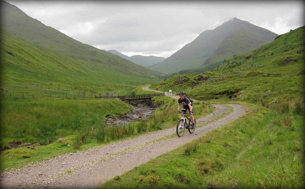
Well, the climb up Glen Croe is both long and strenuous and my body was letting me know i didn't have much in the tank. The forecast had suggested a dry day so i was being pretty minimal By the time the rain hit i was pretty cold. Still, it cleared as i hit Glen Kinglas, and although the trail was far from technical, the view was spectacular as i crossed behind Beinn Chorranach. Onwards and upwards. And upwards.
My map was out of date. I had hoped to find an old walking trail down to the shores of Loch Lomond at Inverarnan, but there was a veritable motorway dropping at about 20% all the way parallel to the Strath Dubh-uisge, and i popped out just south of the Drovers with the rotors smoking. Down the road to Inveruglas and then the pinch up the access road to Loch Sloy all was going well. Yes, i had been bitten by my 3rd horsefly (where are they all coming from this year?) but it wasn't far now to the bealach and the (hopefully) rewarding drop down Glen Loin.

As i mentioned before, my map must have been a little out of date, because it showed the trail running under the power lines as they cross from the interchange next to the Inveruglas Water. As i dropped down the the river, with the hope of picking up the trail on the other side, not only were the greasy rocks and fast flowing water a problem, but as i looked at my arms i saw a carpet of thousands of midge. My face, neck, arms and legs were literally crawling. The nips were plentiful and i threw caution to the wind and leapt across the last section of river and commenced that freaky dance anyone who is outdoors in Scotland bewtween may and september will recognise as i batted and wiped. The hump up the west bank was hard and i hit a horrible bog/tussock double act under the power lines as i got over the bank. Lovely. Talk about the path of most resistance. After 30 minutes of brutal hike-a-bike and several near-submergings in bog water i got to some high ground and spotted the trail on the far northwest corner of the bog-field. Ah well, get on with it. 10 meters from the trail i saw that it did indeed wind all the way back, it was just very well hidden from view. Just to make sure, i followed it back to the river out of pure bitterness. Damn. It was also in an entirely different position to the maps suggestion...
Anyway, after a fairly rapid and loose drop down Glen Loin i was back at the car in Succoth. 4 and a half hours of effort and a pretty reasonable loop. Although it was far from a technical, best-trail-ever sort of ride, it was great to have been out and got some interesting passes under tyre. I have a vague notion for an extended bike-pack trip around here and this helps immensely.
Resource:
Map.
OS map 364.
No comments:
Post a Comment